Fifteen regular sites along the Diani and Chale coastline, each described the same way: location and boat time from the centre, topography, suggested navigation, marine life, and conditions.
Which one you dive on a given morning is decided by the tide, the wind and the divers on board — not by your hotel or a rota. The dry northeast monsoon, roughly November to April, gives the calmest seas, warmest water (26–29°C) and best visibility across nearly every site. Whale sharks and manta rays are the headline seasonal draw, most reliably sighted somewhere between October and March depending on the site.
Your own maximum depth follows your certification and the day's conditions, and is agreed at the briefing. Navigation lines and depth points below are planning notes — the boards used at the briefing are the operative version.
01
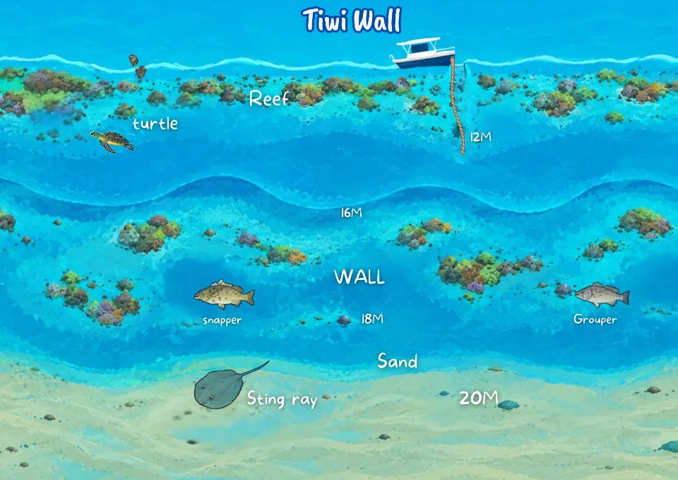
Tiwi Wall
3–27 m40 minWall / drift
Diani's only true wall dive, sitting off Tiwi Beach near the mouth of the Kongo (Mwachema) River, about 11 km north of central Diani.
Topography & navigation
Top reef plateau: 3–6 m, flat coral gardens.
Mooring line reaches the mid-wall at ~12 m; the wall then drops vertically to a sandy floor at 25–27 m.
Face is riddled with overhangs, small caves, and a swim-through tunnel.
Divers descend the mooring line and follow the wall face, keeping it to one shoulder depending on drift direction — shallower rim (down to 12 m) suits Open Water divers, the deep wall and swim-throughs are for Advanced/Deep-certified divers.
Marine life
Sweetlips, red and yellow snappers, triggerfish, Moorish idols, and porcupinefish along the drop-off.
Nudibranchs, cuttlefish, octopuses, lobsters, and mantis shrimp in the crevices.
Blue-ribbon eels, large moray eels, and resting green/hawksbill turtles.
A resident barracuda school patrols the deeper channel; whale sharks and manta rays pass through November–February.
Conditions & timing
Currents mild to moderate; often dived as a drift depending on tide.
Visibility is river-dependent — best at high slack tide, when clean ocean water pushes back the river outflow; rainy-season runoff can cut visibility sharply.
Best window: dry NE monsoon, November–April (26–29°C).
Logistics
~40 minutes by dive boat from the centre; total excursion time is about 4 hours briefing to return.
02
New Place
6–21 m~20 minLinear drift
A fringing reef and drift site, running 1.8 km along the northern part of the reef strip.
Topography & navigation
Reef crest starts at 6 m near the surf line, sloping gradually (no sheer drops) to a sandy floor at 21 m.
Studded with large coral heads and bommies.
Pure linear drift: divers do a negative entry at one end of the 1.8 km line, hold mid-water trim alongside the reef bank, and let the current carry them while the boat tracks the SMB.
Marine life
Reliable green and hawksbill turtles resting by the coral heads.
Dense schools of snappers, sweetlips, surgeonfish, and porcupinefish.
Octopuses, moray eels, scorpionfish, and nudibranchs in the bommies.
Whale sharks and manta rays cruise the outer edge October–March.
Conditions & timing
Gentle, predictable slope — accessible to newly certified divers.
Visibility a reliable 15–25 m, sheltered from river siltation.
Logistics
About 20 minutes by boat from the centre, which regularly runs drift dives here for both fun diving and SSI training.
03
Mwanamochi
10–22 m25 minDrift
A 1.5 km fringing reef just south of central Diani and one of the area's finest drift sites, inside the Diani-Chale Marine National Reserve.
Topography & navigation
Coral plateau begins at 10 m with scattered coral heads; slopes gradually to a sandy base at 22 m.
Centrepiece is a single massive coral head acting as a marine life hub.
Divers drop onto the 10 m shelf, track the sloping bank, orbit the central coral head for turtles, then ascend on the SMB.
Marine life
Reliable green and hawksbill turtle sightings — the site is used by the Olive Ridley Project for turtle monitoring.
Large schools of yellow-striped snappers, triggerfish, and sweetlips around the coral head.
Octopuses, squid, lobsters, blue-spotted rays, and blue-ribbon eels.
The rare helmet flying gurnard on the sandy fringe; whale sharks and manta rays November–February.
Conditions & timing
Mild to moderate currents; a predictable, easy “lazy-river” drift.
Visibility 15–30 m, staying clear through the dry season.
Morning departures recommended — turtles are most active early before retreating to rest.
Logistics
~25 minutes by boat from the centre, which offers full site briefings for certification training plus small-group drift guiding tailored to beginner and intermediate divers.
04
Milele
shallow–25 m15–20 minReef loop
Widely considered Diani's most consistently recommended reef — reliable visibility and an easy layout make it a daily-use site for fun dives and courses.
Topography & navigation
Shallow shelf catching strong sunlight, sloping gently (no abrupt drops) to a sandy floor at 25 m.
Elongated fields of hard and soft coral broken by sandy channels.
Usually run as a slow, U-shaped route rather than a fast drift: drop the mooring line, explore the deeper channels around 20 m, then ascend the coral slope for a safety stop over the shallows.
Marine life
Green and hawksbill turtles regularly resting under coral ledges.
Clownfish in the anemone patches; surgeonfish, Moorish idols, and yellow-striped snappers on the perimeter.
Large moray eels, octopuses, and nudibranchs in the reef framework.
Whale sharks occasionally pass the deeper boundary October–March.
Conditions & timing
Mild to moderate currents; suits everything from a slow marine-life safari to a gentle drift on the tide.
Visibility a reliable 15–30 m.
Logistics
15–20 minutes by boat from the centre, which uses Milele heavily for training dives and daily reef safaris, often paired with a nearby deep site on a two-tank morning.
A 45 m fishing trawler scuttled on 21 February 2002 as the first purpose-sunk artificial reef on the East African coast.
Topography & navigation
Rests fully upright on open sand; deck, holds, bridge, and superstructure are intact.
Superstructure at 17–18 m, main deck at 22 m, hull on the sand at 28–31 m.
Wheelhouse and cargo areas can be penetrated by wreck-trained divers.
Fixed-line profile: descend the mooring line to the superstructure, circle the hull at ~30 m, rise to the deck/wheelhouse at 22 m, and return up the same line for the safety stop.
Marine life
Blue-striped snappers, batfish, fusiliers, trevallies, and chevron barracuda around the upper mast.
Soft corals, sponges, and hydroids on the hull; giant groupers, lionfish, and bearded scorpionfish in the shadows.
Garden eels, gobies, pistol shrimp, and giant thorny stingrays on the sand at 30 m.
Whale sharks occasionally pass overhead during the NE monsoon.
Conditions & timing
Advanced Open Water or Deep Adventure certification required to reach the base; Nitrox recommended to extend bottom time at 31 m.
Currents mild to strong open-ocean surge; this is a stationary, line-tethered dive, not a drift.
Logistics
~15 minutes by boat from the centre, which runs SSI Advanced and Wreck Specialty courses directly on the vessel and schedules two-tank mornings pairing the wreck with a shallower reef.
06
Jadini
7–25 m20 minMulti-level reef
Nicknamed the “Garden of Corals,” sitting just north of Kisima Mungu — vibrant, relaxed, and easy to navigate.
Topography & navigation
Shallow rim at 7 m with strong coral growth; gentle, uniform slope (no drop-offs) to a sandy floor at 25 m.
Complex coral heads, anemone fields, and sandy channels.
Relaxed multi-level route: weave through the sandy channels at the 20 m boundary, then move up to the 12 m anemone beds to extend bottom time.
Marine life
High resident turtle population, including a local favourite nicknamed “Tortellini” — turtles are monitored here by the Olive Ridley Project.
Crocodile fish, scorpionfish, and octopuses camouflaged in the sand and lower reef edge.
Clownfish in the anemones; surgeonfish, Moorish idols, and yellow-striped snappers on the slope; moray eels and nudibranchs in the crevices.
Conditions & timing
Mild currents; Open Water divers can stay in the sunny 10–12 m band, Advanced divers can work the deeper perimeter to 25 m.
Visibility 15–25 m, well sheltered from river runoff.
Logistics
~20 minutes by boat from the centre, which runs frequent morning excursions here for marine-life safaris and refresher courses.
07
Kisima Mungu (“God's Well”)
14–28 m15 minDrift
One of the most distinctive reefs on the southern Diani coast: dramatic drop-offs plus a rare freshwater spring welling up from the seabed.
Topography & navigation
Reef crest at ~14 m, heavily covered in coral; steep walls and undercuts drop to sand at 24–28 m.
The spring surfaces around 24 m, creating a visible halocline (shimmering fresh/salt water mixing).
Usually run as an advanced drift: drop to the 24 m sandy floor to see the spring and check the wall cavities for the resident whitetip, then ascend to the 14 m rim to drift with the current.
Marine life
A cleaning-station coral bommie swarmed by glassfish and damselfish.
Lionfish, scorpionfish, leaf fish, and stonefish on the sea fans and whip corals.
A resident whitetip reef shark resting in a small cave at ~20 m.
Guitar rays, blue-spotted stingrays, and turtles in the sandy channels; rare macro finds like the Indian walkman and weedy scorpionfish.
Conditions & timing
Intermediate–Advanced only; depth typically 18–28 m with open-ocean exposure.
Currents moderate to very strong; run as a fast drift.
Visibility 20–30 m outside the localised halocline shimmer. Peak whale shark season is November–February.
Logistics
~15 minutes by boat from the centre, which runs deep-reef and drift training here and offers fully guided trips, especially in whale shark season.
08
Igloo
10–22 m10 minReef + wreck feature
Named for a sunken underwater observatory nicknamed “The Igloo” (or “the Death Star”), sitting level with the Papillon Lagoon Reef Hotel near the Robinson sand island.
Topography & navigation
Coral plateau at 10–12 m sloping uniformly to sand at 20–22 m.
The observatory wreckage — dome-shaped with metal panel framework — sits on the sand at 20 m and now functions as an artificial reef.
Divers descend the reef slope, cross the sand to the structure at 20 m, orbit it to see the sheltering sweetlips, then use the natural slope to ascend gradually.
Marine life
Sweetlips, large batfish, and pufferfish sheltering inside the structure.
Ghost pipefish, leaf fish, blue-ribbon eels, snake eels, and octopuses camouflaged around the metal joints and sand.
Green turtles resting against the structure; squid schools above the reef rim.
Whale sharks pass the outer edge November–February.
Conditions & timing
Intermediate (Advanced Open Water) rated — solid mid-depth buoyancy needed around the structure.
Mild to moderate currents; visibility generally excellent, away from river inlets.
Logistics
~10 minutes by boat from the centre, which runs daily morning launches here and offers small-group, personalised reef safaris.
A turtle sanctuary and beginner-friendly reef/pinnacle system, sitting parallel to a protected sea-turtle nesting beach.
Topography & navigation
Crest at 6 m, sloping gently to broad sandy channels and coral bommies around 18 m.
Deep outer fringe reaches 24–25 m, though most recreational profiles average 14–15 m.
Flexible loop: from the permanent mooring buoy, circle from bommie to bommie across the sand, using the high-contrast terrain to navigate back.
Marine life
Near-guaranteed green and hawksbill turtles under table-coral overhangs.
Ghost pipefish, frogfish, leaf fish, crocodile fish, ribbon eels, and nudibranchs (including Spanish dancers) around the bommies.
Snappers, fusiliers, parrotfish, and sergeant majors above staghorn and brain coral; blue-spotted ribbontail rays in the sandy corridors.
Whale sharks, manta rays, and guitar rays along the outer edge November–February.
Conditions & timing
Beginner to Intermediate; calm, mild currents and 25–29°C water year-round.
Both deep and shallow eco-moorings in place. Heavily used for checkout dives, refreshers, and photography training.
Logistics
~10 minutes by boat from the centre, which uses Galu for daily reef safaris.
10
Mwanyaza
8–20 m (25 m outer)10 minOne-way drift
A 1.6 km inshore fringing reef south of the “Baobab Mango” boundary, level with the Pinewood Beach Resort — a vibrant one-way drift highway.
Topography & navigation
Sun-drenched crest at 8–10 m, sloping uniformly (no sheer drops) to sand at 18–20 m (outer extensions to 25 m).
Permanent eco-mooring; heavy coral formations with sandy corridors cutting through.
Classic one-way drift: enter at one end, coast with the current while the boat tracks the SMB.
Marine life
Frogfish, ghost pipefish, nudibranchs, and mantis shrimp in the lower crevices.
Angelfish, butterflyfish, parrotfish, lobsters, and octopuses in the staghorn and brain coral.
Large schools of yellow-striped snappers and fusiliers sweeping the upper slope.
Green and hawksbill turtles napping between coral heads; dolphin pods seasonally.
Conditions & timing
Beginner–Intermediate; shallow max depth allows long bottom times.
Water 25–29°C; visibility a reliable 15–30 m.
Logistics
~10 minutes by boat from the centre (based at Galu Beach), which runs small-group guided drift and specialty-training dives along this southern reef line.
11
Dzinani
9–22 m15 minCurrent-aware patch reef
An offshore patch reef system level with Kinondo, made up of three distinct coral clusters over open sand — good for navigation practice and macro life.
Topography & navigation
Western side starts at 9 m, sloping to a max of 20–22 m on the outer perimeter; average cruising depth ~14 m.
Three coral clusters (large brain and staghorn coral) separated by broad sandy corridors.
Current-aware boat dive rather than a pure drift: descend to the central mooring point and island-hop between the three clusters via the sand channels, returning to the anchor line.
Marine life
Notable for rarer macro: Pegasus dragonfish, cryptic frogfish, ribbon eels, and leaf fish in the coral cavities.
Red snappers and yellow-striped fusiliers between the mounds; octopuses and moray eels on the coral heads.
Blue-spotted ribbontail rays and camouflaged crocodile fish on the sand between islands.
Green turtles reliably napping on the shallow sides; whale sharks and eagle rays occasionally on the deeper outer edge in season.
Conditions & timing
Beginner–Intermediate on the shallow inner patches; the deeper outer edge suits more advanced divers managing current.
Outer edge can run strong even while the inner side stays calm. Water 26–29°C, reliably clear.
Logistics
~15 minutes by boat from the centre, which runs dedicated macro-focused trips here; the southern location also allows quick, customised small-group trips to other Kinondo-area sites.
12
Kinondo
8–31 m20 minMulti-level wall/reef
Named for the adjacent Kinondo region (home to the sacred Kaya Kinondo Forest) — a quieter, far-southern site with unusually varied topography.
Topography & navigation
Reef crest at 8–10 m with diverse hard coral; terrain mixes gentle slopes and sudden steep walls down to a sandy base at 30–31 m.
A smaller satellite reef sits just south at ~20 m with its own micro-habitats.
Multi-level route: advanced divers drop straight down the outer wall to the 30 m sand and the 20 m moray patch, then step up to the shallow 8–10 m crest to extend no-decompression time.
Marine life
The 20 m satellite reef is known for unusually large moray eels.
Snappers, goatfish, redtooth triggerfish, and large groupers on the crest and walls.
Barracuda and Napoleon wrasse in the deeper channels; blue-spotted stingrays and crocodile fish on the sand.
Seahorses on gorgonian fans in calmer pockets; turtles reliable, with whale sharks, manta rays, and dolphins October–March.
Conditions & timing
Intermediate–Advanced for the full profile (beginners can stay on the 8–15 m plateau).
Visibility 15–30 m; water 25–29°C; mild to moderate currents, run as either a multi-level tour or a wall drift depending on the tide.
Logistics
~20 minutes by boat from the centre (based near Galu Beach) — one of the fastest-to-reach southern sites, with dedicated advanced deep-reef training excursions.
13
Chale Island — Chale Corner & Gazi
6–25 m / 18–25 m35 min / 40 minHouse reef loop / channel drift
The waters around Kenya's only private island resort, roughly 12 km south of Diani. Two distinct zones: Chale Corner (the sheltered house reef) and Gazi (a deeper outer channel).
Topography & navigation
Chale Corner: gently sloping fringing reef, crest at 6–10 m, averaging 14 m, with sandy outer margins to 25 m. Navigated as a relaxed, shallow horseshoe loop back to the boat.
Gazi: a deeper offshore plateau at a consistent 18–22 m with dramatic undercuts and overhangs facing the open ocean. Run as an advanced channel drift, tucking under the overhangs to shelter from current.
Marine life
Chale Corner: blue-spotted stingrays and guitar rays over the sandy breaks; snappers, sweetlips, batfish, and triggerfish on the reef edges; nudibranchs, ghost pipefish, leaf fish, mantis shrimp, and octopuses in the crevices; active cleaner-wrasse stations.
Gazi: kingfish, giant trevally, and eagle rays hunting in the more open water.
Whale sharks and manta rays are among the most reliable in East Africa here November–February; green turtles nest on the island's beaches.
Conditions & timing
Chale Corner suits Open Water beginners through experienced divers; Gazi is strictly for experienced divers due to depth and exposure.
Water 25–30°C; visibility 15–30 m in peak months.
Chale has an extreme 4 m tidal range — dives are timed to slack tide to manage current and clarity.
Logistics
Chale Corner: ~35 minutes by boat from the centre. Gazi: ~40 minutes (or about 10 minutes from Chale Island itself).
14
Papa Mashilingi
8–17 m
15
Shimo la Samaki
11–20 m
How a site gets chosen
Before the boat leaves we look at the tide state, the wind direction, yesterday's visibility and the certification levels on board, and choose the site that will dive well that morning. It is often not the one anybody expected.
Kisite-Mpunguti Marine Park is a full-day excursion rather than one of the regular morning sites: further offshore, protected for decades, with park fees payable per visitor and dolphins often met on the crossing.
each of the 15 sites has its own map — click one to open it full size
Depths, navigation lines and marine life above come from the centre's own site guide and briefing notes. The briefing board on the boat remains the operative version for any dive.
Who you will dive with
Seven people run the centre, four of them born and raised in Diani Beach. Between the four instructors sit more than 13,000 logged dives on this stretch of the Indian Ocean. Two qualified dive guides, Sampuli and Captain Michael, guide dives alongside them.
Ali
Founder · Divemaster Instructor
25+ years diving in Kenya and abroad. Born and raised in Diani Beach.
Kassim
Scuba Instructor
17+ years and 8,000+ logged dives, from Diani to Kisite Mpunguti. SSI and PADI certified.
Salim Swaleh
Scuba Instructor
4,000+ logged dives on Diani sites. Teaches SSI beginner to specialty courses.
Omari
Scuba Instructor
SSI and PADI Open Water Instructor, 1,000+ logged dives. Shoots underwater photo and video.
Sampuli
Dive Guide
Born and raised in Diani Beach. 100+ logged dives. Guides guest divers and runs equipment checks.
Michael
Dive Guide · Captain
20+ years scuba diving and captaining boats. Handles the boat and guides dives.